
Project Information
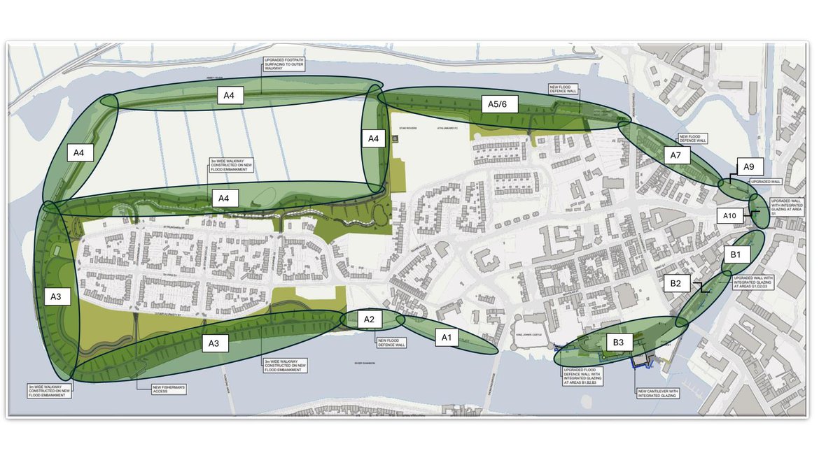
King’s Island lies in the heart of Limerick City and is surrounded by the waters of the River Shannon and the Abbey River. Both the River Shannon and the Abbey River are tidal at this location and the island is susceptible to both coastal and fluvial flood risk. The study focuses on King's Island, and includes the earth embankments around the north, east and west, and the stone walls along Sir Harry's Mall and George's Quay along with the currently undefended areas behind the castle, the City Hall and the court house. A particular area of interest is Verdant Place, which has low level walls but is vulnerable to flooding from high tides.
Very significant flooding occurred in spring 2014 when the existing defences failed locally allowing flood waters onto the Island.
Major improvements to the flood defence regime are required to try to prevent re-occurrences of such flood events. With this in mind, Limerick City and County Council appointed Arup to assess, develop and design an appropriate viable, cost-effective and sustainable flood relief scheme which aims to minimise risk to human beings, the existing community, social amenity, environment and landscape character.
This website has been set up to provide information to members of the public and to keep you informed of the project's progress.
Project Partners
The following organisations form the basis of the Steering Group for the Flood Relief Scheme. We meet on a quarterly basis to discuss the progress of the project and review project challenges that we have come across or can see arising.

Are you prepared?
Even with flood defences in place, you can never entirely remove the risk of flooding. It is important that you and your neighbours prepare for such an event. Guidance is available for members of the public to help them to plan and prepare.
Flooding.ie is a dedicated website that provides information to members of the public to help them to plan and prepare to protect their properties in the event of a flood. It includes information on developing a flood plan, putting together a flood kit and guidance on what to do during and after a flood.
Glossary of Terms
Appropriate Assessment: An assessment based on best scientific knowledge, by a person with ecological expertise, of the potential impacts of the plan on the conservation objectives of any Natura 2000 Environmentally Protected sites (including Natura 200 sites not situated in an area encompassed by the plan or scheme) and the development, where necessary of mitigation or avoidance measures to preclude negative effects.
Breach of defences: A structural failure at a flood defence allowing water to flow through.
Catchment: The area that is drained by a river or artificial drainage system.
Catchment Flood Risk Assessment and Management Studies (CFRAMS): A catchment-based study involving an assessment of the risk of flooding in a catchment and the development of a strategy for managing that risk in order to reduce adverse effects on people, property and the environment. CFRAMS precede the preparation of Catchment Flood Risk Management Plans (see entry for FRMP). Limerick City is covered by the Shannon CFRAM (http://www.shannoncframstudy.ie/)
Climate change: Long-term variations in global temperature and weather patterns, which occur both naturally and as a result of human activity, primarily through greenhouse gas emissions.
Coastal Flooding: Flooding from the sea which is caused by higher than normal sea levels and/or high waves resulting in the sea overflowing onto the land.
Detailed flood risk assessment: A methodology to assess flood risk issues in sufficient detail and to provide a quantitative appraisal of flood hazard and potential risk to an existing or proposed development, of its potential impact on flood elsewhere and of the effectiveness of any proposed measures.
Estuarine (Tidal) flooding: Flooding from an estuary, where water levels may be influenced by both river flows and tidal condition, with the latter usually being dominant.
Flash Flood: A flash flood is a rapid flooding of an area of land as a result of intense or extreme rainfall events or failure of infrastructure designed to store or carry water or protect against flooding and is distinguished from general flooding by the sudden onset.
Flooding (or inundation): Flooding is the overflowing of water onto land that is normally dry. It may be caused by overtopping or breach of banks or defences, inadequate or slow drainage of rainfall, underlying groundwater levels or blocked drains and sewers. It presents a risk only when people, human assets and ecosystems are present in the areas that flood.
Flood defence: A man-made structure (e.g. embankment, bund, sluice gate, reservoir or barrier) designed to prevent flooding of areas adjacent to the defence.
Flood Relief Scheme (FRS): A scheme designed to reduce the risk of flooding at a specific location.
Flood Risk Management (FRM): FRM combines the function of mitigating and monitoring flood risks and may include pre-flood, flood event or post flood activities.
Flood Hazard: The features of flooding which have harmful impacts on people, property or the environment (such as the depth of water, speed of flow, rate of onset, duration, water quality etc).
Flood Plain: A floodplain is any low-lying area of land next to a river or stream, which is susceptible to partial or complete inundation by water during a flood event.
Flood Risk: An expression of the combination of the flood probability, or likelihood and the magnitude of the potential consequences of the flood event.
Flood Storage: The temporary storage of excess run-off, or river flow in ponds, basins, reservoirs or on the floodplain.
Flooding Directive: The EU Directive 2007/ 60/ EC of 23 October 2007 on the assessment and management of flood risks which is aimed at integrating the way flood risk is managed throughout the European Union transposed into Irish Law under SI122/2010.
Fluvial flooding: Flooding from a river, stream or other watercourse.
Groundwater flooding: - Flooding caused by groundwater escaping from the ground when the water table rises to or above ground level.
Freeboard: factor of safety applied for water surfaces. Defines the distance between normal water level and the top of a structure, such as a wall or embankment.
Habitat: A place in which a particular plant of animal lives. Often used in the wider sense referring to major assemblages of plants and animals found together.
Likelihood (probability) of flooding: A general concept relating to the chance of an event occurring. Likelihood is generally expressed as a probability or a frequency of a flood of a given magnitude or severity occurring or being exceeded in any given year. It is based on the average frequency estimated, measured or extrapolated from records over a large number of years and is usually expressed as the chance of a particular flood level being exceeded in any one year. For example, a 1 in 100 or 1% flood is that which would, on average, be expected to occur once in 100 years, though it could happen at any time.
Ordnance Datum (or OD) Malin - is a vertical datum used by an ordnance survey as the basis for deriving altitudes on maps. A spot height may be expressed as AOD for "above ordnance datum". Usually meansea level (MSL) is used for the datum. In the Republic of Ireland, OD for the Ordnance Survey of Ireland is Malin Ordnance Datum: the MSL at Portmoor Pier, Malin Head, County Donegal, between 1960 and 1969. Prior to 1970, Poolbeg Ordnance Datum was used: the low water of spring tide at Poolbeg lighthouse, Dublin, on 8 April 1837. Poolbeg OD was about 2.7 metres lower than Malin OD.
Overtopping of defences: Failure of a flood defence when flood water reaches levels that are higher than the flood defence level and flows over the top of the structure. While the structure may remain stable, erosion of the landward face of the defence could cause the defence to collapse.
Mitigation: The term is used to describe an action that helps to lessen the impacts of a process or development on the receiving environment. It is used most often in association with measures that would seek to reduce negative impacts of a process or development.
Natura 2000: The EU-wide network of protected areas, recognised as ‘sites of Community importance’ under the EC Habitats Directive (Council Directive 92/43/EEC on the conservation of natural habitats and of wild fauna and flora). They comprise “Special Areas of Conservation” (SACs) under the Habitats Directive and “Special Protection Areas” (SPAs) under the Birds Directive (Council Directive 79/409/EC on the conservation of wild birds).
Pathways: These provide the connection between a particular source (e.g. High River or tide level) and the receptor that may be harmed (e.g. property). In flood risk management, pathways are often ‘blocked’ by barriers, such as flood defence structures, or otherwise modified to reduce the incidence of flooding.
Pluvial flooding: Usually associated with convective summer thunderstorms or high intensity rainfall cells within longer duration events, pluvial flooding is a result of rainfall-generated overland flows which arise before run-off enters any watercourse or sewer. The intensity of rainfall can be such that the run-off totally overwhelms surface water and underground drainage systems.
Precautionary approach: The approach to be used in the assessment of flood risk which requires that lack of full scientific certainty, shall not be used to assume flood hazard or risk does not exist, or as a reason for postponing cost-effective measures to avoid or manage flood risk.
Resilience: Sometimes known as “wet-proofing”, resilience relates to how a building is constructed in such a way that, although flood water may enter the building, its impact is minimised, structural integrity is maintained, and repair, drying & cleaning and subsequent reoccupation are facilitated. Resistance, sometimes known as “dry-proofing”, this relates to how a building is constructed to prevent flood water entering the building or damaging its fabric. Receptors Things that may be harmed by flooding (e.g. people, houses, buildings or the environment).
Source: refers to a source of hazard (e.g. the sea, heavy rainfall).
Surface water management: This activity focuses on the assessment and management of flood risk within the urban environment from sources primarily resulting from intense rainfall. Surface water management should understand the performance of the urban drainage network, where exceedance flow routes would form and what impact this would have. Solutions to surface water flood risk can involve green infrastructure provision to capture and direct these exceedance flows to lower vulnerable areas or open space. New development can provide solutions to reducing runoff not only from the proposed development but also from existing areas. This should be considered in the SFRA in critical areas where development is planned upstream of flooding hotspots.
Vulnerability: The resilience of a particular group of people or types of property or habitats, ecosystems or species to flood risk, and their ability to respond to a hazardous condition and the damage or degree of impact they are likely to suffer in the event of a flood. For example, elderly people may be more likely to suffer injury, and be less able to evacuate, in the event of a rapid flood than younger people.
Water Framework Directive (WFD): A European Community Directive (2000/ 60/ EC) designed to integrate the way we manage water bodies across Europe. It requires all inland and coastal waters to reach “good status” or “good ecological potential” in the case of heavily modified water bodies by 2015 through a catchment-based system of River Basin Management Plans (RBMP), incorporating a programme of measures to improve the status of all natural water bodies.
Project Plan
Project Stages
Stage I Optioneering, Screening/Scoping & Advanced Contract (2015-2018)
-
Constraints Identification
-
Public Consultations
-
Options Assessment
-
Environmental Scoping
-
Advanced Contract at Verdant Place - Design & Construction
Stage II Environmental Assessment & Detailed Design (2019-2024)
-
Finalise Preliminary Design
-
Natura Impact Statement
-
Environmental Impact Assessment Report
-
Statutory Approval (An Bord Pleanala)
-
Detailed Design
-
Tender Documentation Preparation
Stage III Tender (2024)
-
Issue of Main Contract Tender
-
Tender Assessment
-
Contractor Appointment
Stage IV Construction (2024 - 2026)
-
24month Construction Phase
Stage V Handover to Client (2027)