News

Construction Progress Update: Aerial Site Overview
Tuesday February 10 2026
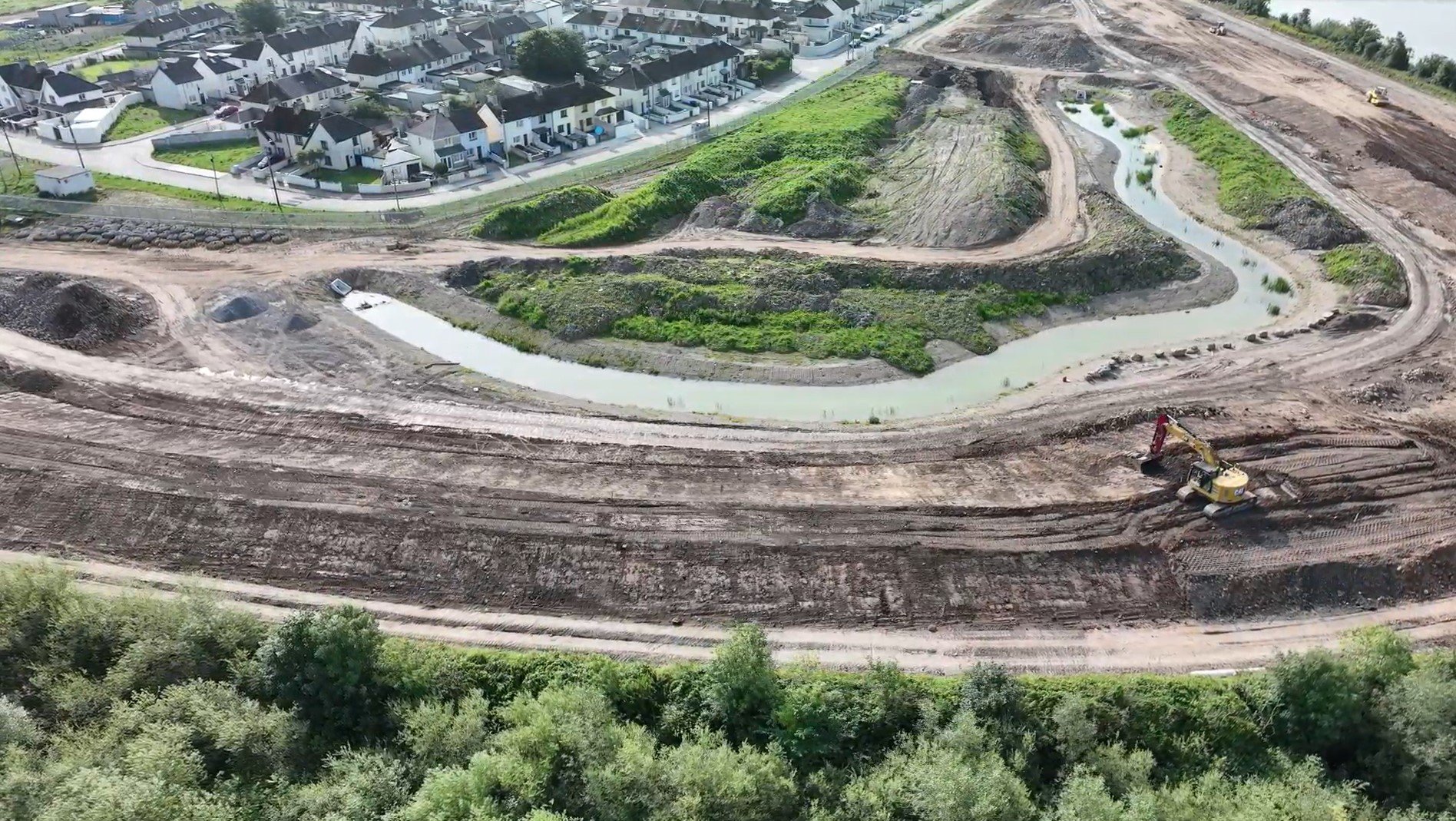
We are pleased to share recent aerial footage documenting the current status of construction. Captured via drone in December 2025, this visual update provides a comprehensive overview of site development achieved to date across the Island.
Archaeological investigations are ongoing at Sir Harry's Mall and the eastern end of Geroge’s Quay where medieval walls have been found running through the site close to the quay wall. The video link above shows the archaeological dig ongoing on Sir Harry's Mall.
Construction Progress Update: Aerial Site Overview
Monday September 30 2025
We are pleased to share recent aerial footage documenting the current status of construction. Captured via drone in August 2025, this visual update provides a comprehensive overview of site development achieved to date across the Island.
Football Clubs and Assumpta Park
Site Works Progressing
Friday September 12 2025
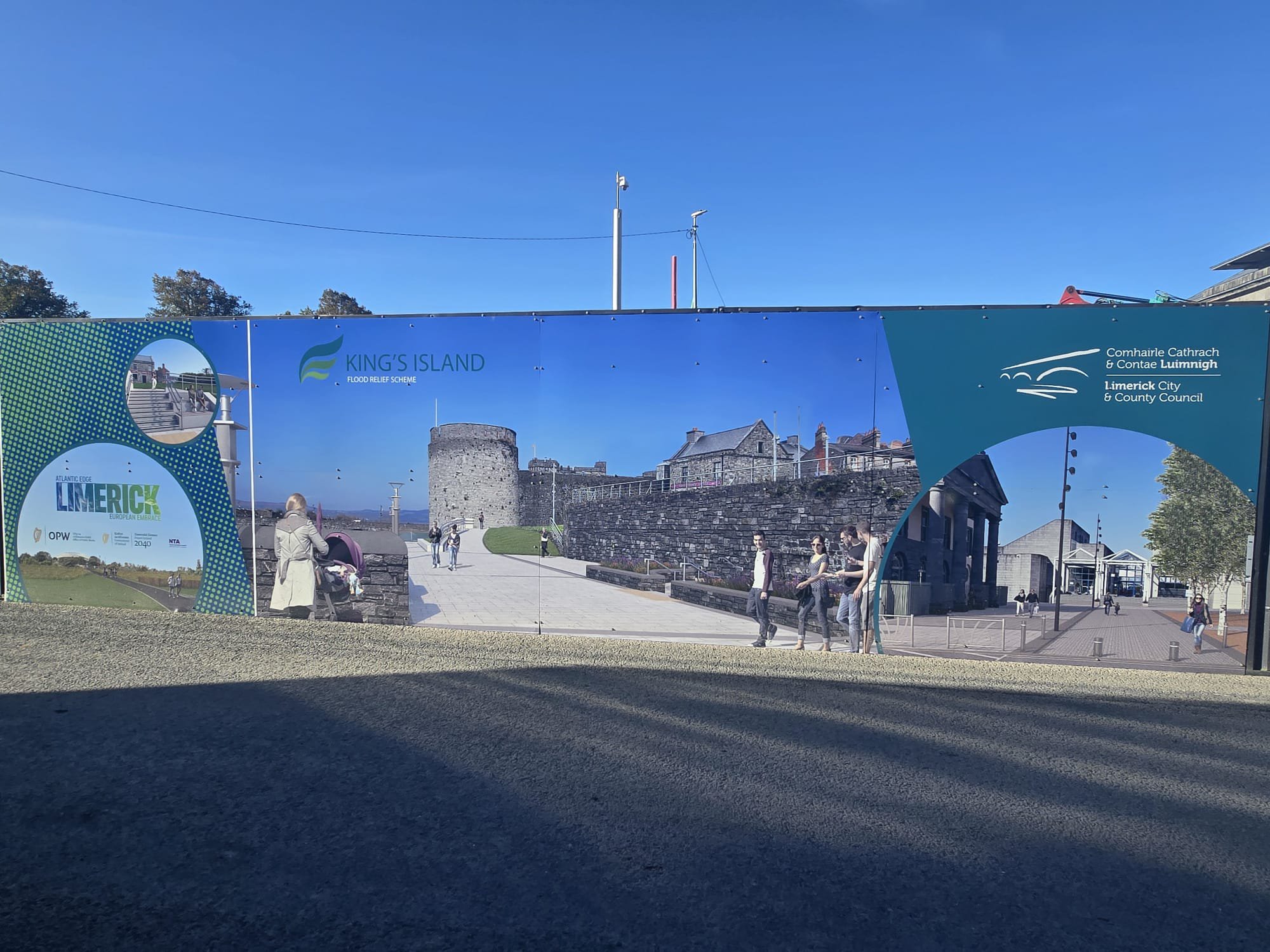
Ward & Burke Construction Ltd commenced works on the King's Island Flood Relief Scheme in Limerick City in October 2024. To keep the public informed, Limerick City and County Council provides regular updates on the progress of the scheme, including newsletters, road closure notices, and safety advisories.
For the latest updates, please visit:
King's Island Flood Relief Scheme | Limerick.ie

Contract Signing
Monday September 30 2024
Limerick City and County Council, in conjunction with the Office of Public Works (OPW), is pleased to announce the signing of the main contract for the King's Island Flood Relief Scheme with Ward & Burke Construction Ltd.
Mayor of Limerick, John Moran, expressed his enthusiasm for the project, stating: 'After years of planning it is great to see this project get underway for real. By investing in these robust defences, we are not only protecting homes and business but also saving the future of King's Island.'
Minister of State for the Office of Public Works, Kieran O'Donnell TD, welcomes the progress on the scheme saying, 'As Minister for the Office of Public Works, and TD for LImerick City, I am delighted to be here today to announce the contract signing for King's Island Flood Relief Scheme. This marks a significant milestone for the project that will see major improvements to the flood defences in Limerick City, protecting 506 homes and 22 businesses.'
See further information on press release at the following website links:

Press Release - Mayor of Limerick welcomes progress
Monday September 2 2024
The Mayor of Limerick, John Moran welcomes progress on King's Island Flood Relief Scheme saying,
"The construction of the King's Island Flood Relief Scheme will bring peace of mind to hundreds of residents and business owners. This investment is an important piece of the jigsaw as we seek to revitalise this historic part of Limerick City. In my Mayoral Programme, I have made a commitment to prioritise investment in King's Island and work on a development plan to incorporate all of the surrounding areas."
See further information on press release at the following website link:
Mayor of Limerick Welcomes Progress on King’s Island Flood Relief Scheme | Limerick.ie

Press Release - OPW Approval to Commence Appointment of a Contractor
Monday September 2 2024
The Minister of State with responsibility for the Office of Public Works (OPW), Kieran O'Donnell T.D., announced that his Office has given approval to Limerick City & County Council, to commence appointment of a contractor for the construction of the King's Island Flood Relief Scheme.
See further information on press release at the following website link:

Tender Issued
Friday February 16 2024
We are delighted to confirm the tender notice for King’s Island Flood Relief scheme is now published on etenders.gov.ie. CFT reference is 3100335. Closing date for receipt of tender submissions is the 25th April 2024.
European Dynamics - View CfT Workspace (etenders.gov.ie)
The King’s Island Flood Relief Scheme primarily consists of:
- 2,200 metres of 2.5-metre-high earthen flood embankment involving importation of 97,300m3 of Class 2F core fill and 55,400m3 of Class 4 Landscape fill with 3-metre-wide footpath/cycleway and public lighting
- Flood defence upgrades to existing quay walls involving:
- Deconstruction of existing quay walls and parapets
- Lime mortar repointing, lime grouting and stonework repair to 870 metres of existing quay walls, approximately 4 metres high
- Construction of:
- 290 metres of flood defence walls with glass panels
- 810 metres of stone clad reinforced concrete flood defence walls
Associated works include:
- Topsoil stripping, site clearance and fencing
- Mass concrete backing wall foundations with lime mortar spray on inside face of quay walls
- 2 No. automatic rising and demountable flood barriers
- 3 No. below ground inter-tidal storage tanks, structural volume of 750m3, 445m3 and 390m3
- 600 metres of access routes to flood embankment walkway and new fisherman’s access
- 800 metres upgrade to outer walkway including cutting down of existing sheet piles
- 6,400m2 of road resurfacing and reconstruction
- 7,600m2 of granite and limestone paving
- Ground beams, piling, micro-piling, vibro concrete columns and ground anchors
- Utility diversions including Limerick Main Drainage sewer, watermains, electrical, surface water sewers, telecommunications, gas mains, cctv and spare ducting
- Demolition of 3 No. pumping stations and construction of new gravity foul sewer with directional drilling
- Consolidation of historic mill and 4 No. sets of access steps into Shannon and Abbey rivers
- Cutting and reusing existing stonework and new stonework to flood defence walls
- Removal of railing and cantilever around Courthouse and construction of new cantilever and repositioning railing
- Raking out and re-pointing quay wall with lime mortar at Verdant Place
- Railings, public lighting, topsoiling and landscaping
- Conservation mitigation
- Archaeological mitigation
- Ecological mitigation
Press Release - OPW Approval to Proceed to Tender
Wednesday February 7 2024
The Minister of State with responsibility for the Office of Public Works (OPW), Mr. Patrick O’Donovan T.D., announced approval by the OPW to Limerick City and County Council to proceed with issuing tenders for the construction of the King’s Island Flood Relief Scheme.
See further information on press release at the following website links:
King’s Island Flood Relief Scheme to Seek Main Contractor | Limerick.ie
https://www.gov.ie/en/press-release/fdc69-kings-island-flood-relief-scheme-to-seek-main-contractor/#

Planning Permission Granted
As well as providing integrated flood protection measures, the scheme also includes extensive landscaping and public realm improvements.
In summary, the works will include a replacement railing on Verdant Place and an extension of the flood defence wall at the rear of the creche/ community centre, construction of a contoured earthen embankments opposite Oliver Pluntkett Street as far as the tie in with the outer embankment at the north end of the island, relocation of open drain in north west corner of Saint Mary’s Park to the toe of proposed earthen embankment, cutting down of existing sheet piles on outer embankment and repair of existing walkway, construction of a contoured earthen embankment to the rear of Saint Munchin’s Street which extends through Star Rovers and Athlunkard Football Clubs and the green areas of Lee Estate / Abbey View as far as Athlunkard Boat Club. The scheme includes the relocation of the astro turf pitch including floodlighting and the provision of fencing and ball stops at playing pitches. A three metre wide footpath / cycleway including public lighting is proposed on top of the earth embankment with pedestrian linkage to Saint Mary’s Park. The proposed works include for the construction of new flood defence wall at Athlunkard Boat Club with new vehicular entrance and internal access roadway, raising a section of existing wall along Sir Harry’s Mall with footpath alteration, replacement of existing parapet along George’s Quay with a new quayside flood defence parapet and section of glazed flood defence panels, road raising at junction of Bridge Street, replacement of cantilever opening in Potato Market with glazed flood defence panel, provision of pedestrian steps / ramps at the pedestrian bridge into the Potato Market and a new flood defence wall on the western edge of the Potato Market. The proposed works include the construction of a vehicular ramp with automatic flood barrier near the entrance of Curragower Boat Club with a new wall between Curragower Boat Club and the Courthouse. Works in Merchants Quay involved the setting back of existing railings and removal of cantilever walkway around the Courthouse and provision of a new cantilever with glazed flood defence panels. There is a combination of glazed flood defence panels and flood defence parapets proposed from the Courthouse as far as King John’s Castle. The scheme includes for the construction of a gravity fed foul sewer from the rear of the Civic Offices to George’s Quay and decommissioning of three foul sewer pumping stations, construction of two inter tidal storage tanks and a new surface water network in Merchants Quay and George’s Quay. The proposed works include for road re-construction, road regrading, drainage works, tree felling, tree planting, landscaping and all associated and ancillary works.

RFI Submission to An Bord Pleanála
Notice Pursuant to: Section 226 of the Planning and Development Act 2000, as amended and the Planning and Development Regulations 2001, as amended Limerick City and County Council proposes to seek approval from An Bord Pleanála for the following proposed development: King’s Island Flood Relief Scheme.
The proposed works are located in King’s Island in Limerick City. King’s Island is situated in the centre of Limerick City and is surrounded by the waters of the River Shannon and the Abbey River. The island is characterised by two distinct areas, the northern portion is known as St. Mary’s Park, a residential development of mostly two storey semi-detached dwellings and surrounded by large green areas, which act as a natural buffer running along the river’s edge. To the south is Englishtown, which runs along the south west of the island, and is regarded as the historic core of Limerick City, home to cultural buildings like St. Mary’s Cathedral and King John’s Castle and includes restaurants, businesses and some residential dwellings built along the water’s edge and is generally considered the more urban area of the island.
The proposed works consist of a replacement railing on Verdant Place and an extension of the flood defence wall at rear of crèche/community centre, construction of a contoured earthen embankments opposite Oliver Plunkett Street as far as the tie in with the outer embankment at the north end of the island, relocation of open drain in north west corner of St. Mary’s Park to the toe of proposed earthen embankment, cutting down of existing sheet piles on outer embankment and repair of existing walkway, construction of a contoured earthen embankment to the rear of St.Munchin’s Street which extends through Star Rovers and Athlunkard Football Clubs and the green areas of Lee Estate Abbey View as far as Athlunkard Boat Club. The scheme includes for the relocation of the astro turf pitch including floodlighting and the provision of fencing and ball stops at playing pitches. A three-metre wide footpath/cycleway including public lighting is proposed on top of the earthen embankment with pedestrian linkages to St. Mary’s Park. The proposed works include for the construction of new flood defence wall at Athlunkard Boat Club with new vehicular entrance and internal access roadway, raising a section of existing wall along Sir Harry’s Mall with footpath alteration, replacement of existing walls to the rear of Absolute Hotel as far as Baal’s Bridge, replacement of existing wall along George’s Quay with new flood defence wall and sections of glazed flood defence panels, road raising at junction of Bridge Street, replacement of cantilever opening in Potato Market with glazed flood defence panel, provision of pedestrian ramp/steps at the pedestrian bridge into the Potato Market and a new flood defence wall on the western edge of the Potato Market. The proposed works include for the construction of a vehicular ramp with automatic flood barrier near the entrance to Curragower Boat Club and a new wall between Curragower Boat Club and the Courthouse. Works in Merchant’s Quay involve the setting back of existing railings and removal of the cantilever walkway around the Courthouse and provision of a new cantilever with glazed flood defence panels. There is a combination of glazed flood defence panels and flood defence walls proposed from the Courthouse as far as King’s John’s Castle. The scheme includes for the construction of a gravity foul sewer from the rear of Civic Offices to George’s Quay and decommissioning of three foul sewer pumping stations, construction of two inter tidal storage tanks and a new surface water network in Merchant’s Quay and George’s Quay. The proposed works includes for road reconstruction, road regrading, drainage works, tree felling, tree planting, landscaping and all associated and ancillary works. The proposed development is subject to a separate application for a foreshore licence.
An Environmental Impact Assessment Report (EIAR) and a Natura Impact Statement (NIS) have been prepared in respect of the proposed development.
The application for permission, EIAR and NIS will be available for inspection free of charge, or may be purchased on payment of a specified fee (which fee shall not exceed the reasonable cost of making such a copy) during public opening hours (excluding Public Holidays and Offices of An Bord Pleanála closed on 27th December 2019 and Limerick City and County Council Offices closed 24th & 27th December 2019), from 23rd December 2019 to 14th February 2020 (inclusive of both dates), at the following locations:
- The Offices of An Bord Pleanála, 64 Marlborough Street, Dublin 1, D01 V902
- Limerick City and County Council, Corporate Headquarters, Merchant’s Quay Limerick, V94 EH90
The application plans and particulars, the EIAR and NIS may also be viewed at or downloaded from the following website mypoint.limerick.ie
Submissions or observations may be made in writing only to An Bord Pleanála (‘the Board’) 64 Marlborough Street, Dublin 1, D01 V902 in respect of:
- The implications of the proposed development for proper planning and sustainable development in the area concerned, and
- The likely effects on the environment of the proposed development, if carried out, and
- The likely significant effects of the proposed development on a European site, if carried out.
Any submissions / observations must be accompanied by a fee of €50 (except for certain prescribed bodies) and must be received by the Board not later than 5.30 p.m. on 14th February 2020. Such submissions or observations must include the following information:
- The name of the person, authority or body making the submission or observation, the name of the person, if any, acting on behalf of that person, authority or body, and the address to which any correspondence relating to the application should be sent,
- The subject matter of the submission or observation, and
- The reasons, considerations and arguments on which the submission or observation is based in full.
An Bord Pleanála may give approval to the application for development with or without conditions or may refuse the application for development.

COVID-19 - Planning & Development consent implications
-
Extension to the time periods for public comment
-
Extensions to the time periods for consultation on environmental assessments
-
Extensions to time limits to lodge an Appeal or seek Judicial Review

An Bord Pleanála Submission
The proposed works are located in King’s Island in Limerick City. King’s Island is situated in the centre of Limerick City and is surrounded by the waters of the River Shannon and the Abbey River. The island is characterised by two distinct areas, the northern portion is known as St. Mary’s Park, a residential development of mostly two storey semi-detached dwellings and surrounded by large green areas, which act as a natural buffer running along the river’s edge. To the south is Englishtown, which runs along the south west of the island, and is regarded as the historic core of Limerick City, home to cultural buildings like St. Mary’s Cathedral and King John’s Castle and includes restaurants, businesses and some residential dwellings built along the water’s edge and is generally considered the more urban area of the island.
The proposed works consist of a replacement railing on Verdant Place and an extension of the flood defence wall at rear of crèche/community centre, construction of a contoured earthen embankments opposite Oliver Plunkett Street as far as the tie in with the outer embankment at the north end of the island, relocation of open drain in north west corner of St. Mary’s Park to the toe of proposed earthen embankment, cutting down of existing sheet piles on outer embankment and repair of existing walkway, construction of a contoured earthen embankment to the rear of St.Munchin’s Street which extends through Star Rovers and Athlunkard Football Clubs and the green areas of Lee Estate Abbey View as far as Athlunkard Boat Club. The scheme includes for the relocation of the astro turf pitch including floodlighting and the provision of fencing and ball stops at playing pitches. A three-metre wide footpath/cycleway including public lighting is proposed on top of the earthen embankment with pedestrian linkages to St. Mary’s Park. The proposed works include for the construction of new flood defence wall at Athlunkard Boat Club with new vehicular entrance and internal access roadway, raising a section of existing wall along Sir Harry’s Mall with footpath alteration, replacement of existing walls to the rear of Absolute Hotel as far as Baal’s Bridge, replacement of existing wall along George’s Quay with new flood defence wall and sections of glazed flood defence panels, road raising at junction of Bridge Street, replacement of cantilever opening in Potato Market with glazed flood defence panel, provision of pedestrian ramp/steps at the pedestrian bridge into the Potato Market and a new flood defence wall on the western edge of the Potato Market. The proposed works include for the construction of a vehicular ramp with automatic flood barrier near the entrance to Curragower Boat Club and a new wall between Curragower Boat Club and the Courthouse. Works in Merchant’s Quay involve the setting back of existing railings and removal of the cantilever walkway around the Courthouse and provision of a new cantilever with glazed flood defence panels. There is a combination of glazed flood defence panels and flood defence walls proposed from the Courthouse as far as King’s John’s Castle. The scheme includes for the construction of a gravity foul sewer from the rear of Civic Offices to George’s Quay and decommissioning of three foul sewer pumping stations, construction of two inter tidal storage tanks and a new surface water network in Merchant’s Quay and George’s Quay. The proposed works includes for road reconstruction, road regrading, drainage works, tree felling, tree planting, landscaping and all associated and ancillary works. The proposed development is subject to a separate application for a foreshore licence.
An Environmental Impact Assessment Report (EIAR) and a Natura Impact Statement (NIS) have been prepared in respect of the proposed development.
The application for permission, EIAR and NIS will be available for inspection free of charge, or may be purchased on payment of a specified fee (which fee shall not exceed the reasonable cost of making such a copy) during public opening hours (excluding Public Holidays and Offices of An Bord Pleanála closed on 27th December 2019 and Limerick City and County Council Offices closed 24th & 27th December 2019), from 23rd December 2019 to 14th February 2020 (inclusive of both dates), at the following locations:
- The Offices of An Bord Pleanála, 64 Marlborough Street, Dublin 1, D01 V902
- Limerick City and County Council, Corporate Headquarters, Merchant’s Quay Limerick, V94 EH90
The application plans and particulars, the EIAR and NIS may also be viewed at or downloaded from the following websites http://www.kingsislandfrs.ie/downloads/ and https://mypoint.limerick.ie
Submissions or observations may be made in writing only to An Bord Pleanála (‘the Board’) 64 Marlborough Street, Dublin 1, D01 V902 in respect of:
- The implications of the proposed development for proper planning and sustainable development in the area concerned, and
- The likely effects on the environment of the proposed development, if carried out, and
- The likely significant effects of the proposed development on a European site, if carried out.
Any submissions / observations must be accompanied by a fee of €50 (except for certain prescribed bodies) and must be received by the Board not later than 5.30 p.m. on 14th February 2020. Such submissions or observations must include the following information:
- The name of the person, authority or body making the submission or observation, the name of the person, if any, acting on behalf of that person, authority or body, and the address to which any correspondence relating to the application should be sent,
- The subject matter of the submission or observation, and
- The reasons, considerations and arguments on which the submission or observation is based in full.
An Bord Pleanála may give approval to the application for development with or without conditions or may refuse the application for development.

Public Information Day

Project Update - January 2019
Following the Public Consultation Event held in December 2017, the preferred option for the Project has been further refined, taking account of the feedback from local residents and relevant stakeholders.
As part of this work, Nicholas de Jong Landscape Architect has now been engaged to augment the design team, providing landscape and public realm design input.
Planning documentation is now being prepared and a planning application is expected to be lodged with An Bord Pleanála in Q2 2019.

Public Information Day - December 2017
A video fly-through was running throughout the day and provided a bird's eye view of the emerging preferred option and can be seen below.
Thanks for the feedback and questionnaires received on the day. If you wish to return a completed questionnaire, it can be downloaded here and submitted by 15th January to either:
- St. Mary's Aid, The Widows Alms Houses, Nicholas Street, Limerick; or
- JBA Consulting, Unit 24 Grove Island, Corbally, Limerick.

Public Information Day
Wednesday 20th December 2017, 11am - 8pm

Public to have their say on Flood Relief Scheme for King’s Island
Members of the public will be able to have their say on plans for a flood relief scheme for the rest of King’s Island with two information sessions to be held on Wednesday 20th December.
Limerick City and County Council has appointed the Arup JBA team to assess, develop and design a sustainable flood alleviation scheme for King’s Island. The scheme aims to minimise risk of flooding to the existing community, social amenity, environment and landscape following on from the Verdant Place works, which were completed in September.
A public information day is taking place on Wednesday 20 December 2017 from 11am until 3pm at Council Headquarters, Merchant’s Quay, and from 5pm - 8pm at King’s Island Community Centre.
Kieran O’Gorman, Project Manager with Limerick City and County Council said: “The local authority has been working with the Arup JBA team and a range of stakeholders and we’re now pleased to announce a Public Information Day for the emerging preferred scheme option.”
“We are urging residents, businesses and interested parties to attend the public information sessions and submit their views and opinions on the scheme.”
“This is an important point in the project as it marks the last opportunity for providing feedback before the project team starts finalising the preferred option for submission to An Bord Pleanála for planning permission next year.”
JBA’s Project Manager, Declan White continued: “The scheme will be a combination of flood walls and embankments which have been designed to stretch from the north end of Verdant Place, tying into with the completed works, around St. Mary’s Park, along Sir Harry’s Mall and George’s Quay.”
“We recognise the importance of the public space and architecturally significant buildings around Merchant’s Quay so glass walls will continue the defence in this area and will tie-in with the wall of King John’s Castle”.
The emerging preferred option has been developed following extensive hydraulic, ecological and geotechnical analysis. Following completion of the scheme, the whole Island will be benefit from a 1 in 200 year standard of protection; a height in excess of the 2014 flood.
In addition, as far as possible, the scheme will be designed to be adaptable to climate change, and in particular the potential impacts of sea level rise.
Declan explained: “The emerging preferred option is a result of balancing a whole series of constraints, including the needs of those who live and work on the Island, the architectural heritage, future use of public spaces and in particular the Lower River Shannon Special Area of Conservation which covers the north-eastern part of the island.”
“This area is considered to be important on a European, as well as Irish level, and is protected under the EU Habitats Directive and includes riparian woodland, wet grassland and tall-herb swamp which provide food, shelter and cover for mammals and birds including protected species such as otter as well as over-wintering opportunities for migrating birds including Whooper Swans.”
Information about the scheme, including a short film showing a 3D fly-over, will be available for review and comment, and members of the team will be present to discuss the proposals and receive feedback.

Verdant Place Advanced Works Opening
August 2016
The new flood defence scheme and associated roadworks at Verdant Place opened to vehicular traffic and pedestrian use on Friday 1st September.
Very significant flooding occurred in spring 2014 when the existing defences failed locally, both through overtopping and breach. This allowed flood waters onto Verdant Place and the surrounding areas. Major improvements to the flood defences were required to try to prevent re-occurrences of such flood events.
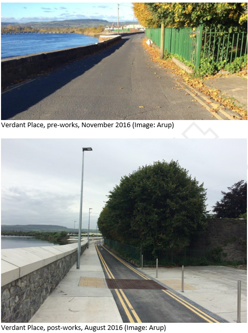
Within the overall flood relief scheme for King’s Island an advance contract to construct a flood defence wall at Verdant Place was progressed. Designed by Arup and JBA Consulting, work began on site in late 2016 and these works have now been completed.
Mindful of the site constraints at Verdant Place, advance works have now been completed which, in conjunction with the main scheme, aims to minimise flood risk to the existing community, social amenity, environment and landscape character.
Having successfully tendered, Wills Bros Ltd. undertook the construction of the works at Verdant Place. The completed works include the following:
- Approximately 220m of new flood defence wall between Thomond Bridge and St. Mary’s Community Centre;
- A new footpath from Thomond Bridge to the Community Centre; and
- Realignment of the existing road to include a one way traffic system with traffic now only permitted to enter at Thomond Bridge.
In addition to providing an improved flood defence to Verdant Place, the newly completed works also improve access for pedestrians to/from St. Mary’s Community Centre, King John’s Castle, Thomondgate and Clancy’s Strand.
Whilst works at Verdant Place have been ongoing, options development and planning is ongoing for the wider King’s Island Flood Relief Scheme and a preferred scheme is expected to be identified later this year.

King's Island Site Investigation Works

Public Consultation Workshop

Phase 1-Construction Works
Works are expected to be complete in Q2 2017.
The planning and associated design for King's Island as a whole is on-going and a preferred scheme is expected to be identified in Q1 2017.

Verdant Place Flood Alleviation Scheme - Public Exhibition
In accordance with Part XI of the Planning & Development Acts 2000-2015 and Part 8, Article 81 of the Planning and Development Regulations 2001-2015, notice is hereby given that Limerick City and County Council proposes to construct flood defences along Verdant Place, King’s Island.
The works to which this advertisement relates are the provision of flood defences along Verdant Place, King’s Island commencing 40m from Thomond Bridge and extending for approximately 238m along Verdant Place. The flood defence works will include:
-
New flood defence walls (ranging from 0.8m and 2.2m higher than existing ground levels);
-
New footpath from Thomond Bridge to the existing embankment at the north of the community centre;
-
Realignment of the existing road to include a one way traffic system;
-
Ancillary works
The proposed works are in the immediate setting and amenities of the following protected structures:
-
The former Thomond Bridge Toll House (City R.P.S. Reg. No. 38);
-
Verdant Place Stretch of the City Wall (City R.P.S. Reg. No. 59);
-
Thomond Bridge (City R.P.S. Reg. No. 428).
Plans and particulars of the proposed works will be available for inspection, or purchase at a fee not exceeding the reasonable cost of making a copy, during normal office hours, Monday to Friday (excluding Bank Holidays), from 29th February 2016 to 15th April, 2016 at Customer Services, Limerick City and County Council, Merchant’s Quay, Limerick, the Travel & Transportation Department, Limerick City and County Council, Dooradoyle, Co Limerick, at the Economic Development and Planning Department, Limerick City & County Council, 7/8 Patrick Street, Limerick and at the Community Centre, Verdant Place, Limerick.
The planning documents will also be available to view during a public exhibition to be held on Tuesday 1st March in the King's Island Community Centre. Click here for further details.
Submissions or observations in relation to the proposed development, dealing with the proper planning and sustainable development of the area in which the works will be constructed may be made in writing to The Administrative Officer, Travel & Transportation Department, Limerick City and County Council, Dooradoyle, Co. Limerick on or before 4.30pm on 29th April, 2016.

Public Consultation Workshop
October 7th 2015, 12pm - 7pm
-
Maintaining / improving fishing and recreation opportunities
-
Respecting the archaeology, ecology and heritage of the island and its buildings
-
Considering visual impact for residents and visitors
-
Keeping up consultation and providing information on progress
-
Ongoing maintenance of the finished scheme
-
Retaining public rights of way
-
Investigate possibilities for increasing access around and across the island
-
Safety for users of walkway and embankments – lighting, CCTV, access

First SAG Meeting held 17 September 2015
September 17th 2015
The first meeting of the Stakeholder Advisory Group (SAG) was held on September 17th 2015. The group has been set up to link the technical and design team with local residents and businesses.
The SAG will function as a forum where the views of the residents of King’s Island can be represented in a structured way. The SAG will be chaired by the Mayor of the Metropolitan Area and include for Councillors and resident representatives.
The first meeting allowed members of the team to introduce themselves and their interests in the Island, as well as begin to express opinions on the development of the scheme options.