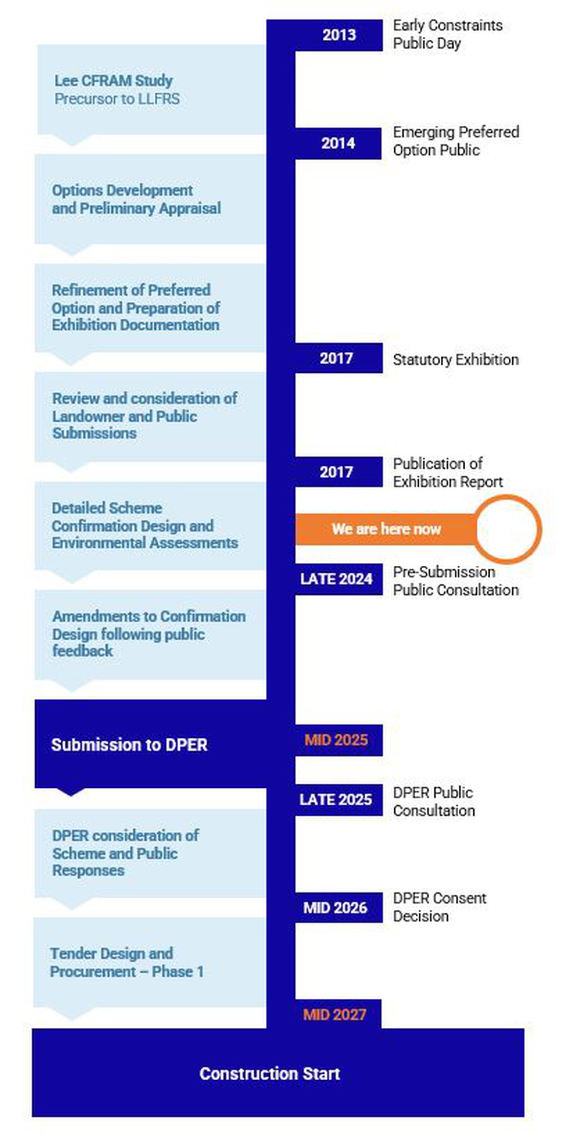
The Evolution of the Scheme

The detailed consideration of flood risk in Cork goes back to 2006 when the Lee was chosen as a catchment for a pilot Catchment and Flood Risk Management Strategy (CFRAMS).

Subsequently, the current design team were engaged to build upon the findings of the CFRAMS and develop a viable, sustainable and effective flood relief Scheme for Cork.

The Lower Lee Flood Relief Scheme represents the result of over a decade of study utilising cutting edge technology to review the most recent data and science, alongside local community needs, and the current and future climate context.

Due to the complex nature of the flood risk in Cork, which can arise from combinations of river and tidal flooding, including the opportunity available with the presence of the two hydroelectric reservoirs, a team of multi-disciplinary experts in the flood risk management field was engaged to ensure that the Scheme design represents the optimum solution for Cork, one which is robust, future proofed, sustainable, environmentally positive and which takes the opportunity to deliver wider placemaking benefits beyond flood relief.

Since the Scheme was statutorily exhibited in 2017, a significant body of additional rainfall and river gauge data has become available, further OPW coastal studies have been completed and the accuracy and resolution of weather forecasts have improved. As a result of this additional data, and to ensure that the design of the Scheme is robust and based on the best available data, a number of additional work packages have been completed in the last few years to further enhance the Scheme.

This work includes a comprehensive update of the tidal level analysis. The impact on water levels of surge from factors such as wind speed and direction, atmospheric pressure and local wave affects (known as seiche) were analysed in detail. This work has now brought the coastal hydrology up to date and provides great confidence in the coastal defence levels required for this scheme.

In addition to the above, the OPW and its consultant have undertaken a full recalibration of the flood forecasting system and its proposed role in further optimising the operation of the ESB dams during flood events. This has further enhanced the performance of the system to further optimise the management of the dams for flood risk management.


Significant Legislative Changes

From the outset of the project, and most notably since the previous public exhibition, there have been a number of significant legislative changes (and changes in industry practice) in the areas of environmental assessment, climate change and biodiversity. The most notable impact was with respect to the environmental impact assessment (EIA) for the scheme, following the transposition into Irish law in 2019 of the European Union (Environmental Impact Assessment) (Arterial Drainage) Regulations 2019, which gave effect to the EU Environmental Impact Assessment Directive 2011/92/EU , as amended by Directive 2014/52/EU. 

The Government’s Climate Action Plans of 2019 and 2023, the OPW’s Climate Change Sectoral Adaptation Plan and Cork City Council’s Adaptation Plan are also informing the latest development and evolution of the Scheme.

The changed legislative and policy framework have led to a significant body of additional empirical analysis and design work being undertaken by OPW and its consultants to ensure that the scheme design meets all of these statutory requirements.

The documents are available below:


European Union (Environmental Impact Assessment) (Arterial Drainage) Regulations 2019


Climate Action Plan 2019


Climate Action Plan 2023 (CAP 23)


Flood Risk Management Climate Change Sectoral Adaptation Plan


Cork City Council Climate Change Adaptation Strategy


Changes in the way we live

Over the last number of years, there has been an evolution of a number of significant cultural and societal aspects. The last few years has seen a shift in focus to more sustainable methods of travel, a shift towards hybrid working, the enjoyment of outdoor spaces, and a greater appreciation of mental health amongst other things.

As a result, the City has seen some significant changes over the last number of years. These include more outdoor dining areas, more cycleways etc.

Parklet at Union Quay

Parklet at Sullivan's Quay

Contra flow Cycle Lane at Merchant’s Quay

Contra flow Cycle Lane at Patrick’s Quay


The Process

The proposed LLFRS is the result of over a decade of study utilising cutting edge technology to review the most recent data and science, alongside local community needs, and the current and future climate context.

Since the outset of the Scheme, the solution has evolved, taking into consideration the valuable public feedback received as well as some significant legislative changes and changes in the way we live that have occurred in recent years. 

The Scheme is being delivery through a process which consists of 5 stages as described below.

Stage 1 – Scheme Development

  • Assess potential options for achieving a scheme to provide flood relief to the areas at risk of flooding from the River Lee downstream of Inniscarra Dam.
  • Design of a flood forecasting system for Cork City and the lower reaches of the River Lee (downstream of Inniscarra) to facilitate decision-making on dam discharges and, if necessary, the erection of temporary / demountable defences downstream and in Cork City.
  • Assessment and development of a scheme to permit greater discharges from the Inniscarra Dam without causing flooding of properties, and to provide protection along the Lower Lee and through Cork City against residual fluvial flooding and flooding from tidal sources.
  • Carrying out a Constraints Study to identify the key environmental issues in the study area, which may be impacted upon by possible flood alleviation measures, and/or which may impose constraints on the viability and/or design of one or more measures.
  • Preparation of an initial Appropriate Assessment Screening Statement.
  • Public consultation, including public information days. The purpose of the first public information day will be to seek initial views from the public and other interested parties in relation to the key issues that the study should address, and to highlight points of local importance to inform the design of potential flood alleviation measures. The purpose of the second public information day will be to gather views of the public about the preferred scheme option in advance of the formal exhibition stage.

Stage 2 – Public Exhibition

  • Public Exhibition of the scheme in accordance with the requirements of the Arterial Drainage Acts, where the public’s view of the proposals will be ascertained.
  • Consideration of observations received from the public and the making of possible amendments to the scheme.
  • Preparation of an Environmental Impact Assessment Report (EIAR) for the scheme.

Stage 3a – Detailed Design, Confirmation and Tender

  • Undertaking the confirmation design of the final preferred scheme.
  • Confirmation of the scheme by the Minister for Public Expenditure & Reform.

Stage 3b – Detailed Design, Confirmation and Tender

  • Undertaking the detailed design of the confirmed scheme.
  • Preparation of contract documents and undertaking the procurement of a works contractor to construct the scheme.

Stages 4 and 5 – Construction and Handover of the Works

  • Supervision of the works.
  • Supervision of the contracts.
  • Handover of the completed works.


The Timeline


The Study Area

The study area consists of:

  • All areas potentially prone to flooding from the River Lee downstream of Inniscara dam to the discharge of the River Lee into Cork Harbour adjacent to Páirc Uí Chaoimh.
  • Tributaries prone to flooding due to a backwater effect from the River Lee are also included.
  • Additional areas where works may potentially be carried out to assist with provision of flood relief measures in the areas described above.
Project Area


Postal address: OPW, 1 George's Quay, Dublin, D02 Y098

Email: lowerleefrs@arup.com

Follow us on Twitter:   @opwireland  @llfrscork | Instagram:   llfrscork | Facebook:  LLFRSCORK

Copyright 2020, All rights reserved

Privacy Statement


OPW's National Flood Information Portal - www.Floodinfo.ie