Background Information
Project Background
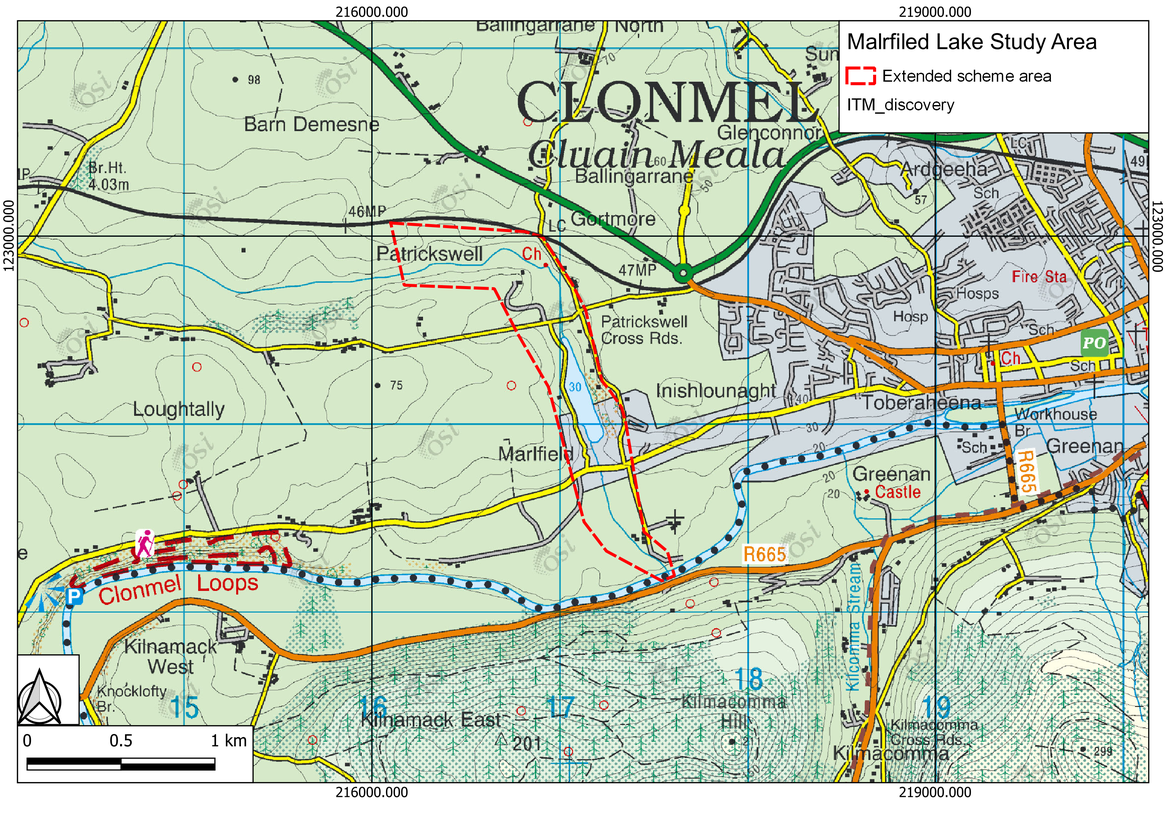
Marlfield Lake is located south west of Clonmel Town just north of Marlfield Village in Co. Tipperary. It is an artificial lake made by damming an unnamed tributary of the Suir River in the early 1770s just outside of Clonmel Town. The dam was created to run mill machinery. The lake covers an area of approximately 5.6 ha. There are several outlets including an overflow weir and at least two sluices. In addition, there are potentially other outlets and swallow holes in the reservoir downstream of the dam which to date have not been fully assessed. One of these outlets (sluices) was in the past operated to lower the reservoir level during times of high flows, however, this practice has since been discontinued and the sluices, not being operated since then have fallen into disrepair.
Flooding from the lake run-off at Marlfield village has occurred on several occasions in the recent past which caused significant damage to some houses immediately downstream. Noted recent flood events include:
- 29th December- 2nd January 2013/2014
- 19th & 20th November 2009
Reports indicate that several properties were flooded during the 2013/2014 event and here is information that there was some dam overtopping during 2009 event which caused flooding in the village as well as surrounding properties. It should be noted that the 2009 event was a significant event nationally with many reports of river flooding across the country due to 3 weeks of persistent rain leading up to the storm of 19th and 20th.
As part of the Government’s National Development Plan 2018-2027, almost €1 billion has been committed to the investment into flood relief measures across the country. Following on from this commitment, a steering group was established between the Office of Public Works (OPW) and Tipperary County Council to progress a flood relief scheme to protect the Marlfield lake and alleviate the risk of flooding for the local community of the peninsula.
The Marlfield lake and Suir Catchment area falls under South eastern River basin District and CFRAM has conducted flood risk study there on 2016. In 2011 South Tipperary County Council commissioned Mott MacDonald to undertake a flood study of Marlfield Lake and outline viable flood risk management options. As part of the study a bathymetric survey of the lake together with a topographic survey of the surrounding area was carried out. These studies outline proposed flood mitigation measures to address the identified risks and how to best manage and mitigate the overall risks to the community.
In September 2021, Tipperary County Council appointed Nicholas O’Dwyer Ltd. (NOD) to develop, design, and construct a Flood Relief Scheme (FRS), that is technically, socially, environmentally, and economically acceptable, for the community of Clonmel. The appointment will cover all five stages which comprises of preliminary design to statutory consents, to detailed design, tendering, construction and handover.
The prelminary options assessment report by CFRM study is Preliminary Options Report (UoM16), the hydraulic model report of Suir catchment is here (Hydraulic Model Details HA16) and the hydrology report is in Suir Hydrology Report.
Project Area
The focus of the Scheme is Marlfield Lake and downstream village which extends from Saint Patrick's well in the North to Suir River to the South, Pond Road to the West and L3218 Road to the East.
The red dashed outline in the map below covers the study area of this Scheme.