Project Documents
River Dodder FAS Phase 3 - Hydrology Report
Ayesa undertook the hydrological assessment for River Dodder FAS Phase 3 - the final report is available under the link below:
River Dodder FAS Phase 3 - Hydrology Report
River Dodder FAS Phase 3 - Environmental Constraints Report
Ayesa undertook an environmental constraints study for River Dodder FAS Phase 3 - the final report is available under the link below:
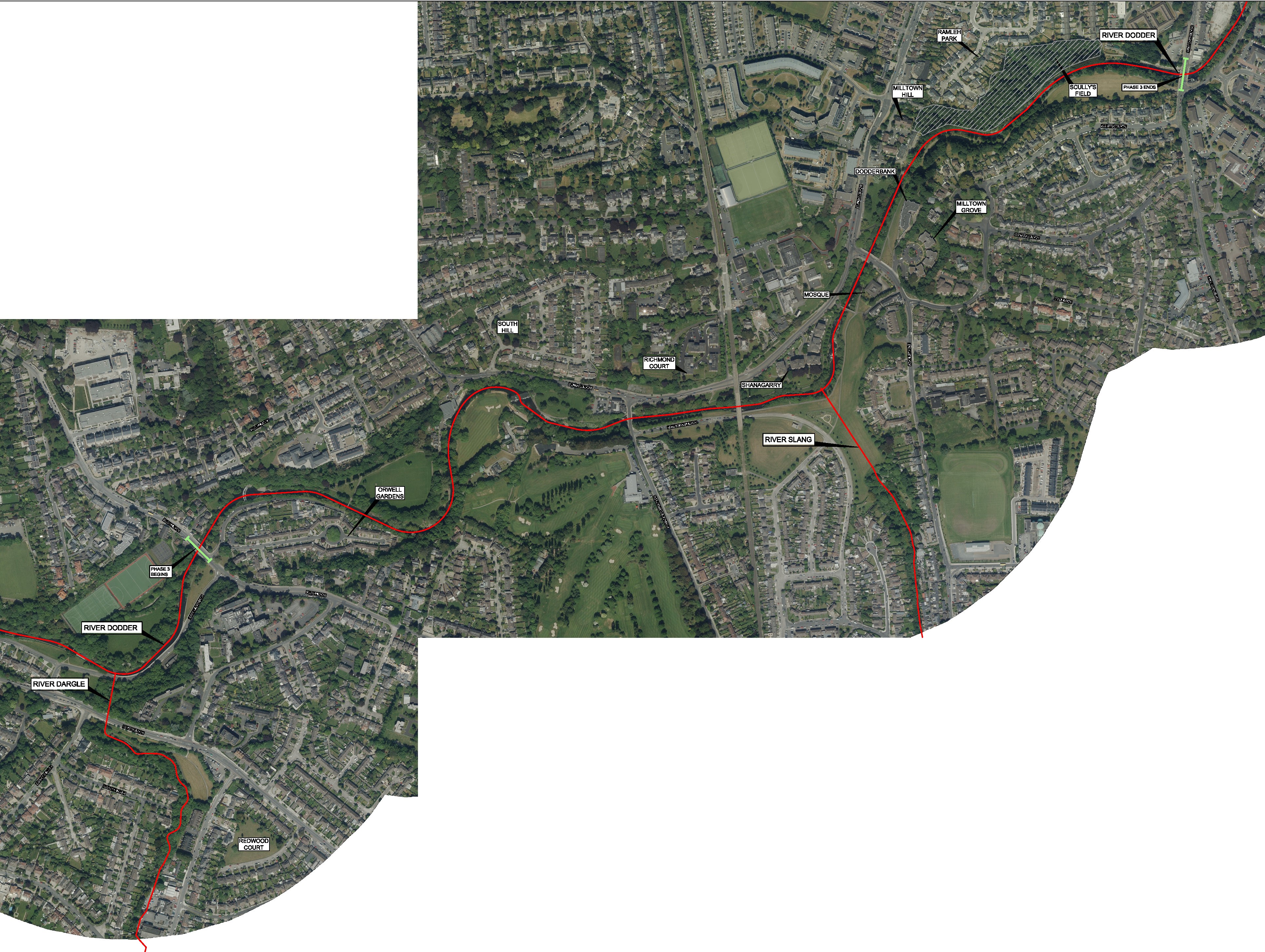
Public Exhibition Map
Below is Location Map for River Dodder Flood Alleviation Scheme Phase 3.
Public Exhibition Drawings
Study Area
The study area covers a section along the River Dodder which includes the following:
- Lengths of river channel/ watercourse that have hydraulic influence on the area intended to benefit from, and be protected by, any feasible scheme
- Full hydrological catchment areas draining to the downstream end which is Clonskeagh Road Bridge
- Places that have the potential to be environmentally impacted from any such scheme
The Focus of the Scheme is between Orwell Road Bridge and Clonskeagh Road Bridge and surrounding environs which include Orwell Gardens, South Hill, Richmond Court, Shanagarry Apartments, Scully’s Field, Milltown Grove, Milltown Hill, Ramleh Park and Dodder Park.
Useful Links
The following are a selection of webpages which provide additional information on flooding and flood management. These links are provided for information only, and Ayesa cannot be held accountable for any information contained on third party websites.
- Catchment Flood Risk Assessment and Management Studies – www.floodinfo.ie
- Flooding.ie – http://www.flooding.ie/
- Dublin City Council – http://www.dublincity.ie/
- Dun Laoghaire-Rathdown County Council – https://www.dlrcoco.ie/
- Office of Public Work- http://www.opw.ie/en/
- Met Eireann – http://www.met.ie/
- National Flood Hazard Mapping – http://www.floodmaps.ie/
- National Parks and Wildlife Services – http://www.npws.ie/
- Realtime Water Level Monitoring -http://waterlevel.ie/
- OPW memorandum of Understanding with Insurance Agencies - https://www.opw.ie/en/completed/
Steering Group
The following organisations form the basis of the Steering Group for the Flood Relief Scheme. We will meet on a monthly basis to discuss the progress of the project and review technical challeneges that we have come across or can see arising.