Project Background and Timeframe
How did we get here?
As part of the implementation of the EU Floods Directive, the OPW undertook the Eastern Catchment Flood Risk Assessment and Management (CFRAM)Study. The objectives of the CFRAM Study were to:
- Identify and map the existing and potential future flood hazard within the CFRAM Study Area,
- Assess and map the existing and potential future flood risk within the CFRAM Study Area,
- Identify viable structural and non-structural options and measures for the effective and sustainable management of flood risk in the Areas for Further Assessment (AFAs) and within the CFRAM Study Area as a whole,
- Prepare a set of Flood Risk Management Plans (FRMPs) for the CFRAM Study Area, and associated Strategic Environmental and, as necessary, Habitats Directive (Appropriate) Assessment, that sets out the policies, strategies, measures and actions that should be pursued by the relevant bodies, including the OPW, Local Authorities and other Stakeholders, to achieve the most cost-effective and sustainable management of existing and potential future flood risk within the Study Area, taking account of environmental plans, objectives and legislative requirements and other statutory plans and requirements.
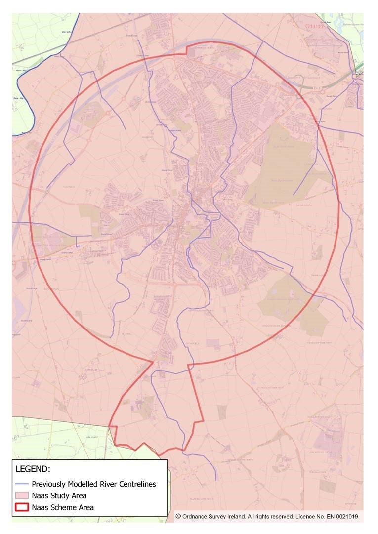
The Eastern CFRAM Study Area included Naas as an AFA, and concluded that a flood relief scheme would be viable and effective for the community. The viable Scheme option for Naas as identified at the CFRAM level of assessment, can be summarised as follows:
- Physical works such as a series of hard defences (flood embankments and walls), storage, formalisation of an existing flow path to create a flow diversion channel and improvement of channel conveyance
- Storage areas located in the upper catchment to attenuate flow on the Morell, Naas and Broadfield Rivers to protect at risk properties
- Hard defences to protect for 1% AEP fluvial flood events
- Diversion of flow and improvement of channel conveyance for other at risk properties
The Project Objective is to advance and implement a flood relief scheme for Naas, if feasible. It is also noted that there is high uncertainty regarding the flood risk in relation to Naas due to the lack of model calibration events and possible interconnection between fluvial and surface water drainage and canal systems. Despite the uncertainty, it was still considered appropriate that the outline of a potential option is developed and progressed in conjunction with the further data collection and analysis.
Note that the above option, along with other potentially viable options will be subject to further engineering assessment as part of this project. The potentially viable options will also be fully appraised as part of the Environmental Impact Assessment process for the scheme.
All relevant CFRAM Study reports are available, for information purposes, from the publications section of www.floodinfo.ie
Project Timeframe
The project will compromise five stages, as follows:
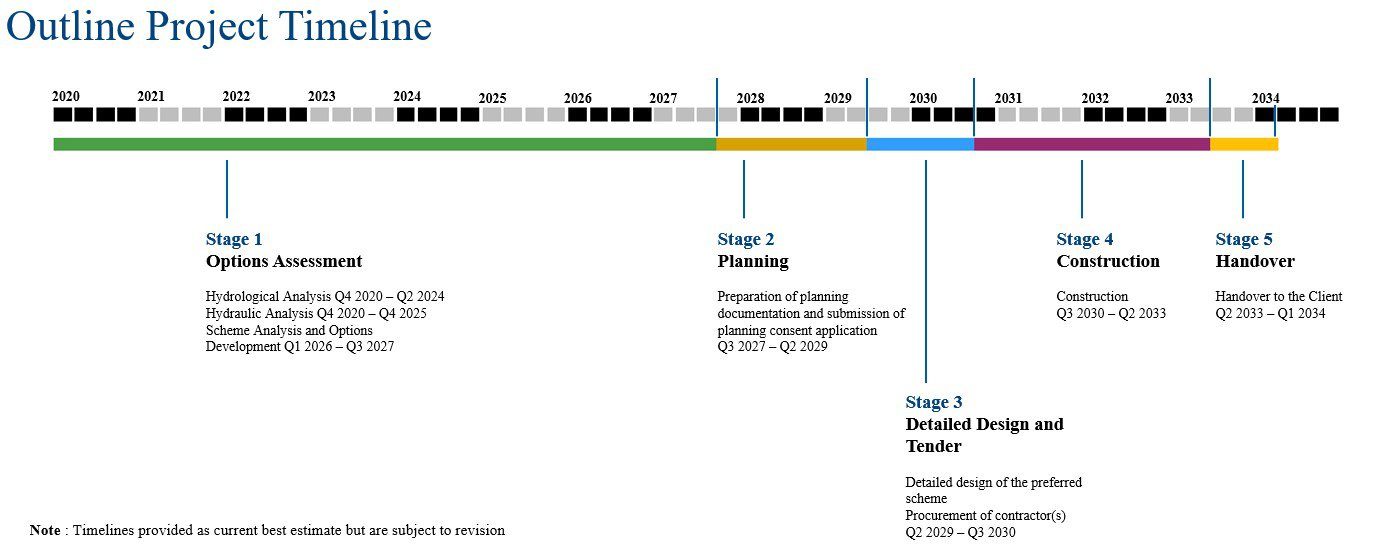
Stage 1 – Options assessment, Scheme Development and Preliminary Design
- Hydrology and hydraulic analysis.
- Procurement of surveys.
- Review and assessment of the technical analysis and preliminary measures identified in the Eastern CFRAM Study Reports and the FRMP for Unit of Management 09
- Carrying out a Constraints Study to identify the key environmental issues in the study area, which may be impacted upon by possible flood alleviation measures, and/or which may impose constraints on the viability and/or design of one or more measures
- Assessment, including technical, environmental, and economic assessments, and through detailed hydraulic modelling, of potential flood risk management options
- Assessment and development of a preferred scheme
- Preparation of an initial Natura Impact Statement and Environmental Impact Assessment Reports Screening
- Public consultation, including public information days. The purpose of the first public information day will be to seek initial views from the public and other interested parties in relation to the key issues that the study should address, and to highlight points of local importance to inform the design of potential flood alleviation measures. The purpose of the second public information day will be to gather views of the public about the preferred scheme option in advance of the formal exhibition stage.
Stage 2 – Detailed Design and Planning/Development Consent Processes
- Producing Natura Impact Statement (NIS) and Environmental Impact Assessment Report (EIAR), if required
- Addendums to the Preliminary design based on the findings of the NIS and/or EIAR (if required)
- Producing a Preliminary Construction Environmental Management Plan
- Provision of all documentation required to progress the scheme through the necessary planning and other statutory processes
- Provision of addendums to the Environmental Assessments as a result of the outcomes/conditions of the planning process
Stage 3 – Detailed Construction Design and Tender
- Undertaking and completing the detailed construction design of the Scheme
- Preparation of Construction Contract Documents and undertaking the procurement of a works contractor to construct the scheme
Stages 4 – Construction
Stages 5 – Handover of Work
Project Area