Project Background and Timeframe
How did we get here?
As part of the implementation of the EU Floods Directive, the OPW undertook the Shannon Catchment Flood Risk Assessment and Management (CFRAM) Study. The objectives of the CFRAM Study were to:
- Assess and map the existing and potential future flood risk within the CFRAM Study Area.
- Identify viable structural and non-structural options and measures for the effective and sustainable management of flood risk in the Areas for Further Assessment (AFAs) and within the CFRAM Study Area as a whole.
- Prepare a set of Flood Risk Management Plans (FRMPs) for the CFRAM Study Area, and associated Strategic Environmental and, as necessary, Habitats Directive Appropriate Assessment (AA), that sets out the policies, strategies, measures and actions that should be pursued by the relevant bodies, including the OPW, Local Authorities and other Stakeholders, to achieve the most cost-effective and sustainable management of existing and potential future flood risk within the Study Area, taking account of environmental plans, objectives and legislative requirements and other statutory plans and requirements.
The Shannon CFRAM Study Area included Ballinasloe as an AFA, and concluded that a flood relief scheme would be viable and effective for the community. The viable Scheme option for Ballinasloe as identified at the CFRAM level of assessment, can be summarised as follows:
- Construction of new flood defence walls, flood defence embankments and demountable flood gates;
- Construction of two new flood alleviation arch culverts at Ballinasloe East Bridge;
- Regarding of the riverbank upstream and downstream of the Ballinasloe East Bridge to maximize efficiency of the flood alleviation culverts;
- Construction of two Lock Gates across the Canal and a sluice gate across the channel flowing into the marina from the canal;
- Upgrade existing culvert at Portnick Drive/Moycarn Drive;
- Upgrade the existing Kilclooney Road Bridge on the River Deerpark;
- Regarding of the riverbed upstream and downstream of Kilclooney Road Bridge to maximize efficiency of the upgraded structure;
- Maintain all existing defences, including the existing flood relief scheme at Derrymullen;
- Maintenance of the West and East Atlas channels to ensure their full capacity can be utilised in a flood event.
Click here to see how this community was assessed (You will be redirected to Floodinfo.ie)
Note that the above option, along with other potentially viable options will be subject to further engineering assessment as part of this project. The potentially viable options will also be fully appraised as part of the Environmental Impact Assessment process for the scheme.
Following the flood of 2009, a flood relief scheme for the Derrymullen area was advanced by Galway County Council. Construction of the scheme was completed in 2011, and involved 1.19km of flood defence structures consisting primarily of walls and embankments. The existing Derrymullen scheme is proposed to be incorporated into the proposed Ballinasloe Flood Relief scheme, which will facilitate the ongoing management and maintenance of a single overall scheme for the town.
All relevant CFRAM Study reports are available, for information purposes, from the publications section of www.floodinfo.ie
Project Timeframe
The project will compromise five stages, as follows:
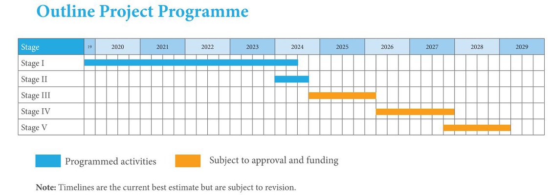
Stage 1 – Scheme Development and Design
- Hydrology and hydraulic analyses.
- Procurement of surveys.
- Review assessment of the proposed measures identified in the Shannon CFRAM Study Reports and the FRMP for Unit of Management 26.
- Assess potential options for achieving a scheme to provide flood relief to the areas at risk of flooding in Ballinasloe.
- Assessment and development of a preferred scheme to provide protection along the River Suck and through Ballinasloe against residual fluvial flooding.
- Carrying out a Constraints Study to identify the key environmental issues in the study area, which may be impacted upon by possible flood alleviation measures, and/or which may impose constraints on the viability and/or design of one or more measures.
- Preparation of an initial Appropriate Assessment Screening Statement, Natura Impact Statement and Environmental Impact Assessment Reports.
- Public consultation, including public information days. The purpose of the first public information day will be to seek initial views from the public and other interested parties in relation to the key issues that the study should address, and to highlight points of local importance to inform the design of potential flood alleviation measures. The purpose of the second public information day will be to gather views of the public about the preferred scheme option in advance of the formal exhibition stage.
Stage 2 – Statutory Public Exhibition
- Public Exhibition of the scheme in accordance with the requirements of the Arterial Drainage Acts, where the public’s view of the proposals will be ascertained.
- Consideration of observations received from the public and the making of possible amendments to the scheme.
Stage 3 – Ministerial Confirmation, Detailed Construction Design and Preparation of Work Packages
- Undertaking the detailed design of the final preferred scheme.
- Confirmation of the scheme by the Minister for Public Expenditure & Reform.
- Preparation of contract documents and undertaking the procurement of a works contractor to construct the scheme.
Stages 4 – Construction
Stages 5 – Handover of Works
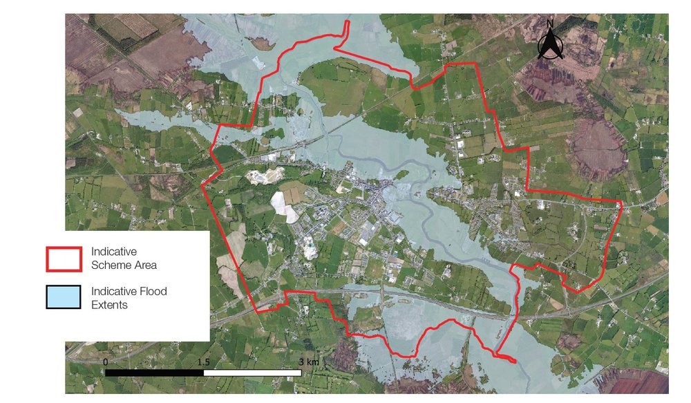
Scheme Area
The map below indicates the area which will benefit from the proposed scheme, which generally consists of all areas potentially prone to flooding from the River Suck and its tributaries in Ballinasloe. Additional areas where works to assist with provision of flood relief measures in the scheme area will also be considered.